


Hengrui radar mud water level gauge, river irrigation area water level gauge, debris flow monitoring, 80G electromagnetic wave continuous frequency modulation
Category:
Instrumentation/Level instrument/Radar level gauge
Model:
HR7380/HR7301
Brand:
Hengrui
model:
HR7380/HR7301
range:
15m 30m 70m
measurement accuracy:
1mm( Within the range of 0-10m
resolution:
Minimum distance resolution=speed of light/working bandwidth/2 ≈ 3cm
power supply voltage:
9~30V
Measuring tube material:
Water level and mud level distance
Explosion-proof rating:
intrinsic safety
Processing & Customization:
No
Overall dimensions:
φ72*72mm
weight:
zero point one
Place of Origin:
Baoji, Shaanxi
manufacturer:
Shaanxi Hengrui Measurement and Control System Co., Ltd
Retail Price
399.00USD
重量
kg
- Product Description
-
model HR7380/HR7301
range 15m 30m 70m
measurement accuracy 1mm( Within the range of 0-10m
resolution Minimum distance resolution=speed of light/working bandwidth/2 ≈ 3cm
power supply voltage 9~30V
Measuring tube material Water level and mud level distance
Explosion-proof rating intrinsic safety
Processing & Customization No
Overall dimensions φ72*72mm
weight zero point one
Place of Origin Baoji, Shaanxi
manufacturer Shaanxi Hengrui Measurement and Control System Co., Ltd
Description :

1.1 Characteristics
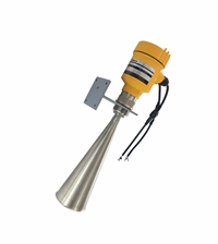
HR7380 Hengrui radar mud water level gauge, river irrigation area water level gauge, debris flow monitoring, 80G electromagnetic wave continuous frequency modulation product, refers to a frequency modulated continuous wave (FMCW) radar product operating at 76-81GHz. The product range can reach 60m, with a blind spot within 10cm. Due to its higher operating frequency, larger bandwidth, and higher measurement accuracy. The product provides a fixing method for the bracket, and the communication method is RS485 or TTL output.
The main advantages of HR7380 are as follows:
Based on our self-developed CMOS millimeter wave RF chip, we achieve a more compact RF architecture, higher signal-to-noise ratio, and smaller blind spots.
The 5GHz working bandwidth enables the product to have higher measurement resolution and accuracy.
The narrowest antenna beam angle is 6 °, and the interference in the installation environment has less impact on the instrument, making installation more convenient.
Integrated lens design with exquisite volume.
1.2 HR7380 Selection Hengrui Radar Mud Water Level Gauge River Irrigation Area Water Level Gauge Mudflow Monitoring 80G Electromagnetic Wave Continuous Frequency Modulation Explanation
According to the signal output form, the selection of HR7380 is as follows.
transmission frequency
76GHz~81GHz
measurement range
0.1 m ~60m
measurement accuracy
±1mm
Beam angle
6°
power supply range
RS485:9~36VDC, Suggested 12VDC/TTL: 3.6-5VDC
contact method
485 / TTL
Operating Temperature
-40~85℃
Shell material
aluminum alloy
Antenna type
lens antenna
Recommended cables
7*0.3mm2
Protection level
IP68
Installation method
support
Table 2-1HR7380 Technical Specifications
2. Installation
Two points to pay attention to during installation: (1) Ensure that the instrument is perpendicular to the water surface, and (2) Avoid emitting beams that interfere with objects and produce false echoes. Typical operating conditions refer to the following points.
Ensure that the water level gauge is installed perpendicular to the water surface. Tilting it will weaken the amplitude of the received signal and affect normal distance measurement.
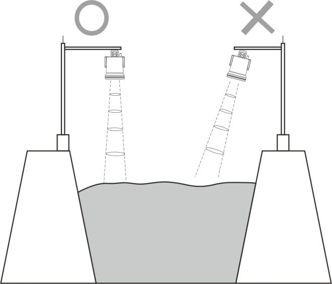
Figure 4-1 Schematic diagram of instrument installation position

Ensure that there are no interfering objects within the beam range, such as riverbanks.
3. Glossary of Terms
Beam angle: The beam width with a 3dB lower ratio as the boundary. The HR7380 beam angle is 6 °, as shown in Figure 10-1.

Figure 10-1 Schematic diagram of radar beam spatial geometry of the instrument
Distance resolution: Distance resolution refers to how far apart two objects are from each other, and the level radar can distinguish between them instead of one object and measure their respective distances. If the distance interval between two objects is less than the distance resolution of the level radar, then the radar can only measure one distance value, which is not equal to the distance value of any one object, but the combination of the distance values of the two objects. The frequency modulation bandwidth of HR7380 is B=5GHz, and the minimum distance resolution is approximately 3cm, which is equal to the speed of light divided by the working bandwidth.
Measurement accuracy: If there is only one object and it has moved a small distance, can the level radar recognize the distance change. The indicator that distinguishes the distance traveled by a single object is called accuracy. The intermediate frequency signal of HR7380 is analyzed using proprietary algorithms, with a measurement accuracy of 0.5mm.
Blind spot: (1) refers to the measurement limit at the near end of the instrument, where the instrument cannot measure within the blind spot
Echo: The reflected signal received by a radar.
Transmitting cone: the extension of the antenna beam angle.
False echo: Any echo that is not generated by the desired target. Generally speaking, false echoes are generated by obstacles in the container.
Multiple echoes: Multiple reflected echoes that appear at the target echo distance, possibly 2 or 3 times.
Range: (1) Refers to the farthest measurement limit of the instrument. (2) Special, refers to the artificially set farthest distance beyond which the instrument does not consider data processing.
Repeatability: The degree of deviation in multiple measurements of the same variable under the same conditions.
Threshold curve: A curve that varies over time, serving as a threshold beyond which echoes are considered valid.

AfterSalesService :
Key words:- Radar mud water level gauge


