


Hengrui Radar Water Level Gauge, Radar Level Gauge Manufacturer, Water Conservancy Informatization Water Level Monitoring. This company has a large shipment volume
Category:
Instrumentation/Level instrument/Radar level gauge
Model:
HR7380/HR7301
Brand:
Hengrui
model:
HR7380/HR7301
range:
15m 30m 70m
measurement accuracy:
1mm( Within the range of 0-10m
resolution:
Minimum distance resolution=speed of light/working bandwidth/2 ≈ 3cm
power supply voltage:
9~30V
Measuring tube material:
Water level and mud level distance
Explosion-proof rating:
intrinsic safety
Processing & Customization:
No
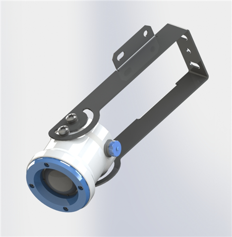
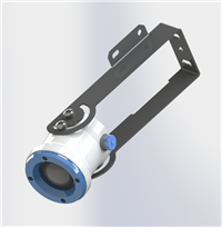
Overall dimensions:
φ72*72mm
weight:
zero point one
Place of Origin:
Baoji, Shaanxi
manufacturer:
Shaanxi Hengrui Measurement and Control System Co., Ltd
Retail Price
399.00USD
重量
kg
- Product Description
-
model HR7380/HR7301
range 15m 30m 70m
measurement accuracy 1mm( Within the range of 0-10m
resolution Minimum distance resolution=speed of light/working bandwidth/2 ≈ 3cm
power supply voltage 9~30V
Measuring tube material Water level and mud level distance
Explosion-proof rating intrinsic safety
Processing & Customization No
Overall dimensions φ72*72mm
weight zero point one
Place of Origin Baoji, Shaanxi
manufacturer Shaanxi Hengrui Measurement and Control System Co., Ltd
Description :

one Glossary
beamcornerThe beamwidth with a 3dB lower ratio as the boundary. The HR7380 beam angle is 6 °, as shown in Figure 10-1.

Figure 10-1 Schematic diagram of radar beam spatial geometry of the instrument
range resolutionDistance resolution refers to the ability of a level radar to distinguish between two objects that are close together, rather than just one, and to measure their respective distances. If the distance interval between two objects is less than the distance resolution of the level radar, then the radar can only measure one distance value, which is not equal to the distance value of any one object, but the combination of the distance values of the two objects. The frequency modulation bandwidth of HR7380 is B=5GHz, and the minimum distance resolution is approximately 3cm, which is equal to the speed of light divided by the working bandwidth.
measurement accuracy:If there is only one object and it has moved a small distance, can the level radar recognize the distance change. The indicator that distinguishes the distance traveled by a single object is called accuracy. The intermediate frequency signal of HR7380 is analyzed using proprietary algorithms, with a measurement accuracy of 0.5mm.
blind spot(1) Refers to the measurement limit at the near end of the instrument, where the instrument cannot measure within the blind zone
echoThe reflected signal received by the radar.
Launch coneExtension of antenna beam angle.
False echoAny echo that is not generated by the desired target. Generally speaking, false echoes are generated by obstacles in the container.
multiple echo Multiple reflection echoes that appear at the target echo distance may be 2 or 3 times.
range(1) Refers to the farthest measurement limit of the instrument. (2) Special refers to the artificially set farthest distance beyond which the instrument does not consider data processing.
repetitivenessThe degree of deviation in multiple measurements of the same variable under the same conditions.
Threshold curveA curve that varies over time, serving as a threshold, beyond which the echo is
The current market for water level gauges generally includes principles such as electromagnetic waves, ultrasonic waves, and lasers (radar mud water level gauges), with priority given to radar mud water level gauges (electromagnetic waves); Ultrasonic waves are mechanical waves, while millimeter waves and lasers are electromagnetic waves. Ultrasonic waves are greatly affected by factors such as temperature, and lasers are also affected. Millimeter waves (radar mud level gauges) have strong all-weather capabilities and are typically suitable for monitoring mud level and debris flow disasters at field stations.
The selection of mud water level timing should mainly consider the following aspects
1: Launch angle, the smaller the angle, the better
2: Power consumption, the lower the power consumption, the better
3: Protection level, protection level IP68
4: Frequency, 80G ≥ 26G ≥ 24G ≥ 60G
5: The lower the anti-interference ability, the better
HR7380 typeMud level gaugemain advantagesWhat is it?
Based on our self-developed CMOS millimeter wave RF chip, we achieve a more compact RF architecture, higher signal-to-noise ratio, and smaller blind spots.
The 5GHz working bandwidth enables the product to have higher measurement resolution and accuracy.
The narrowest antenna beam angle is 6 °, and the interference in the installation environment has less impact on the instrument, making installation more convenient.
Integrated lens design with exquisite volume.
HR7380 typeWhat are the parameters of a mud level gauge?
Table 2-1HR7380 Technical Specifications
transmission frequency
76GHz~81GHz
measurement range
0.1 m ~15m 0.1 m ~30m 0.1 m ~60m
measurement accuracy
±1mm
Beam angle
6°
power supply range
RS485:9~36VDC, Suggested 12VDC/TTL: 3.6-5VDC
contact method
485 / TTL
Operating Temperature
-40~85℃
Shell material
aluminum alloy
Antenna type
lens antenna
Recommended cables
7*0.3mm2
Protection level
IP68
Installation method
support


AfterSalesService :
Key words:- radar water level gauge

")

